Important Information

By Scott Post, PE

Whenever I meet with a new non-motorized trails group or client, one of the first questions I am asked is, “Where can we get grants to pay for our trail?” If your group or community is planning a non-motorized trail, check out my seven favorite trail funding sources:

  1. Michigan’s Natural Resources Trust Fund (For example, Cannon trail)
    Grants a maximum of $300,000 per project. Applications are due April 1 each year.
  2. MDOT’s Transportation Alternatives Program (TAP) (For example, Fred Meijer CIS Trail between Ionia and Owosso)
    Emphasizes regional trail connectivity.
  3. MDOT’s Congestion Mitigation and Air Quality (CMAQ) Improvement Program (For example, Blue Star Trail)
    Can be used if your community is in a non-attainment zone for air quality. Trails can be constructed to provide access for alternative modes of transportation.
  4. Recreation or trails millages (For example, Spring Lake Township)
    Many communities have successfully passed trail millages to use for the development and maintenance of trail projects.
  5. Benefactors and Foundations (For example, Greenville Trail)
    Often local corporations in your community may see this as an opportunity to give back.
  6. Fund Drives (For examples, Big Rapids’ Access for All for the Riverwalk)
    Many local organizations will assist with fundraising for community projects that they support.
  7. MDOT’s Safe Routes to School program (For example, Allegan’s Monroe Street)
    Safe Routes to School funding will require a community non-motorized plan and the adoption of a Complete Streets ordinance.


Scott Post is a board member at the West Michigan Trails and Greenways Coalition. He has designed nearly 150 miles of non-motorized trails in Michigan.

By Jim Hegarty, PE

1. Dream Big

When I was a young engineer, one of my mentors told me this: “There’s no such thing as a money problem, only idea problems.”

In other words…“Good ideas attract money.”

I like to ask my public-sector clients what they would do if money were no object. To start, I have them make a wish list. Write everything down. Everything they want to accomplish for their community.

Why? It is easier to find money on purpose than to rely on luck. It surprises me how many communities react to, rather than plan for, funding opportunities or announcements. When funding becomes available, the first recipients are largely those whose projects were shovel-ready.

Planned. Designed. Ready to go. Defeatists don’t win grants. Visualize the things you want to happen, so when opportunity knocks, your projects are planned, designed, and ready to go.

CHALLENGE:

Gather your staff and community leaders and start dreaming. What would you do if you had the money to do it? Write it down. Everything you can think of. In my next posts, I will suggest some ideas to help you bring your dreams to reality.


2. Network

Pick any project on your wish list—where will you find enough money to make it happen? Look to your network. No, I do not mean ask them for money! They are, however, a key link between you and money. Key people in your network might include:

  • Engineers
  • Planners
  • Attorneys
  • Financial Advisers
  • Peers in other communities
  • Associations (MML, MTA, MLGMA, etc.)

Describe what you want to do, and ask them if they know where you can find favorable financing or a grant. Chances are several of them can point you in the right direction. For smaller projects you might be able to get seed money from local service clubs and charitable or community foundations.

In addition, do not forget your digital resources:


3. Make Your Pitch!

Once you have identified your project and found a prospective funding source, it is time to make your pitch! Usually, this means writing a grant or funding proposal. Every organization has its own proposal format and scoring system. Here are eight key items to include somewhere in your proposal:

  1. Succinctly summarize your proposal in one paragraph or less—it is your headline!
  2. Provide information on how you will manage the grant. Show them that you have managed similar grants before and that their money will be in good hands.
  3. Tailor how you describe your need/project/activity in a way that matches the scoring criteria and the funding program’s objectives.
  4. Outline your work plan and project cost. The more detail you have, the better.
  5. Identify your source(s) of “matching” money. You need “skin in the game” for most grants.
  6. Outline your plan to maintain any physical assets once the funding is gone.
  7. Explain future project phases, if applicable.
  8. Get your grant before you write the proposal!

Item #8 bears some explanation. Before you write any funding proposal, engage the funding organization in a discussion about your project/proposal. Invite them to meet with you. Get their advice and feedback. Moreover, since developing a funding application is time-consuming and expensive, ask them if your project is a good candidate for funding before you begin the application process.


4. Improve your chances for success!

I am convinced that preparation begets luck. I have found when my clients focus on these four things it greatly enhances their chances for funding success:

  • Shovel-readiness: The better defined your project is by the time you apply for funding, the greater your chances for success. You at least should have a well-developed cost estimate and work plan. Preliminary studies, plans or sketches are nice, but completed design plans are better. Better still—have all your regulatory permits in-hand.
  • “Skin”: If you are not willing to bet your own money on a project, why would anyone else? The more you can come up with, the better you will do. Some communities even have “matching funds” as a line item in their annual budgets, so they can take advantage of unexpected opportunities.
  • Collaboration: Many funders like to see multi-party partnerships. It helps them leverage their own good will, and it shows them you have gathered strong support. If you do not have project partners, at least get support letters from other groups and communities.
  • Political Support: You should gather support letters from elected representatives and ask them to promote your project to funding agencies. Be careful, however, not to overstep an agency’s funding process.

You can find more resources in Prein&Newhof’s Grants and Loans Guide.

Happy hunting!

By Jim Hegarty, P.E.

Unlike many Grand Rapidians, I missed the worst of Grand Rapids’ Great Flood of 2013. I was in Clearwater, Florida, reading the national news about our flood from the safety of my beach chair. Being in a relaxed and contemplative state, I began to ruminate about “our” flood in terms as only a civil engineer could.

To whit: The Grand River at downtown Grand Rapids saw its highest water level in over 100 years, but it wasn’t a 100-year flood.

What?

A 100-year flood is one whose flow has a 1% (1 in 100) chance of occurring in a given year. Statisticians study historical flood records to determine mathematically the magnitude of a 100-year flood.  Prior to 2013, Grand Rapids’ weather statisticians figured that the flood with a 1% chance of occurring in a given year is larger than the one that caused the highest water levels we’ve seen downtown in over 100 years!  In reality, the flow we saw in the great Grand Rapids flood equated to only a 16-year flood according to Mark Walton from the National Oceanic and Atmospheric Administration (NOAA) National Weather Service.

Why, then, was the river so high? One word: floodwalls.

The floodwalls channeling the Grand River through downtown Grand Rapids haven’t been there for 100 years, and they raise the water level as the Grand River races between them to a more natural setting downstream. The walls “pinch” the river’s otherwise wide floodplain in this heavily-developed area, increasing both the river’s surface level and its velocity between them. Mayor Heartwell credited the floodwalls with saving the city from a massive flood.

The “100-year flood plain” is the ground elevation contour reached by the theoretical 100-year flood. People living within the 100-year flood plain are eligible for government-backed flood insurance, but only if Federal Emergency Management Agency (FEMA) engineers have calculated and mapped the 100-year flood elevation for a given watershed.

Currently in draft form, FEMA’s updated Grand River floodplain maps show the Great Flood of 2013 remained within the 100-year floodplain because, as explained in the previous paragraphs, it was less than an “official” 100-year flood.

One of the reasons FEMA’s report remains in draft form is that it cannot “certify” that Grand Rapids’ floodwalls will contain the 100-year flood. FEMA’s current “draft” flood model shows that while the 100-year flood in Grand Rapids will not overtop the existing floodwalls, it will come within one foot of overtopping them. By FEMA’s definition a “certified” floodwall must have at least three feet of “freeboard” remaining between the 100-year water level and the top of the floodwall. Because the existing floodwalls are not “certified”, FEMA hydrologists revised their flood model to treat the current floodwalls as if they do not exist. The result, and a cause for great angst among Grand Rapids officials, is that much of the West Side is deemed to be within the 100-year floodplain!

Another irony is that there were no recorded 100-year storms directly preceding the Great Flood of 2013. A 100-year storm is one which has a 1% probability of occurring in a given year. The “storm” is usually rainfall, and in Grand Rapids it takes 6.15 inches of rainfall in a 24-hour period, or 2.8 inches in one-hour, to qualify as a 100-year storm.

Even 100-year storms do not guarantee 100-year floods. Why?

Besides rainfall, a river’s flood level depends on the beginning river depth before the storm and the extent of existing ground saturation. Also, an intense rain may only occur over a small portion of the overall watershed. It’s possible to have a 100-year storm in a dry watershed and not create a 100-year flood. And, as in Grand Rapids’ case, it’s possible to have less than a 16-year storm create a 16-year flood with already-saturated ground and high river levels.


By James R. Hegarty, P.E., Barbara Marczak, P.E., and Brian Vilmont, P.E.

Our infrastructure provides the foundation on which our communities are built: the roads that enable our transportation, the watermains that provide our drinking water, the sewers and treatment plants that put clean water back into our environment, and the buildings upon which our communities depend for services and support. All the assets that make up our infrastructure systems must be managed in order to maintain their value to our communities. Without asset management, our limited funds will continue to be depleted with reactionary repairs instead of leveraged to maximize the value of each dollar spent.

Asset management is not a new concept. The old Aesop fable of the grasshopper, who sings during summer instead of preparing for winter, and the ant, who stores up food for winter during the summer, ended with this lesson: “It is best to prepare for the days of necessity.”  We know that our assets will not last forever, but we can get the most value from them if we invest in their management and maintenance. Like the ant, it is important that we do our work now and not wait for the proverbial winter for our assets to fail. To be able to choose from the many tools available for asset management, it is important to understand the fundamentals first.

How asset management works

The goal of asset management is to provide the desired level of service from our assets at the lowest, long–term costs. Proactive asset management can reduce short–term reactionary expenditures and make the most out of the available funding. To accomplish this, we need to follow these basic steps:

1. Appraisal

  • Identify Assets
  • Document System History & Concerns
  • Determine Existing & Proposed Level of Service
  • Select Desired Management System
  • Develop Work Plan *
    *Required to apply for SAW Grant Funding

2. Inventory

  • Mapping
  • Criticality Review

3. Assessment

  • Condition: Physical  & Capacity
  • Risk
  • Cost: Maintenance & Rehabilitation/Replacement

4. Asset Management Plan

  • Maintenance Strategies
  • Capital Improvement Plan
  • Funding Alternatives & Strategies

5. Implementation

  • Public Education
  • Culture: Staff & Community Investment
  • Funding: Internal & External Sources
  • Tracking & Reporting: Community Dashboard

Grants Available

The State of Michigan is moving forward with funding of asset management plan development for municipalities through  the Stormwater, Asset Management, and Wastewater (SAW) Grants. Later this summer, MDEQ will accept grant applications for this program, providing up to $2,000,000 in grant funding per municipality. SAW Grants will be awarded on a first–come, first–served basis. For more information about Asset Management Plans and MDEQ SAW Grants, contact Jim Hegarty, P.E.,  Brian Vilmont, P.E. at (616) 364–8491, or Barbara Marczack, P.E. at (231) 798-0101.

If you own property, someone likely has told you that you need a survey. Did you know there are different types of surveys? Download this free white paper to learn more about surveys, what the terms surveyors use actually mean, and answers to many frequently asked questions. Download the white paper here.

Not everyone is aware of downtown development authorities (DDA), or why they are important. Many cities have one, and Michigan has 35 of them. Prein&Newhof often works with DDAs on projects related to streetscapes and downtown infrastructure.

Downtown is considered the heart of the city. It is an expanse of a few streets that are pedestrian-oriented and often show the historical aspect of the community.  It is an important driver for commerce, a stage for public events, and a representation of the city’s identity.

Many cities’ development has focused on suburbs and subdivisions in the last 60 years. This pattern stems from the invention of cars and streetcars.  Streetcar suburbs are now often the main thoroughfares of major cities, since we build where transportation is available. Although downtown living has been abandoned in the past century, the resurgence in the last ten years has been significant. We still value our downtowns and direct special funds and efforts to keep them vibrant.

DDAs use incremental property taxes from downtown property owners to make public improvements, which encourage private investment. DDAs are formed by the municipal government after public hearing and approval, and are given boundaries as a district.

Place-based economic development has become a popular issue in response to the economic recession of the last few years. Michigan cities have seen that local identity can drive local commerce, which stabilizes local economies.

Prein&Newhof was happy to be involved with the design of Greenville’s streetscape for M-91, which built the character and identity of Greenville’s downtown and was partially funded by Greenville’s DDA.

Do you think downtowns are worth our investment?

Sometimes it’s useful to be able to map data. That’s why we have Geographic Information Systems, a powerful relational database and information mapping program that takes some training to use and understand.

Luckily for us, ArcGIS offers access maps and mapped data online, on an interface as easy-to-use as Google.

ArcGIS Explorer  allows you to not only view different map types, by choosing the basemap, but also to add data on top of the basemap to show information like population density, racial diversity, and median income.

Basic

IMPORTANT: Before you start, it’s good to know that you cannot save a map unless you have a (free) account with ArcGIS online. (Click the “Sign In” button the upper right corner to sign up.)

  • From the main page, which shows already-made maps, you can click the “New Map” on the upper left corner to start your own map.
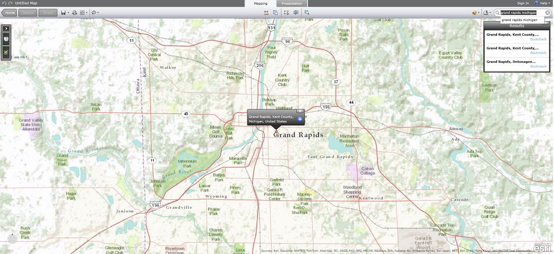
  • In the search bar on the upper right corner, put in your town, eg: “Grand Rapids Michigan”
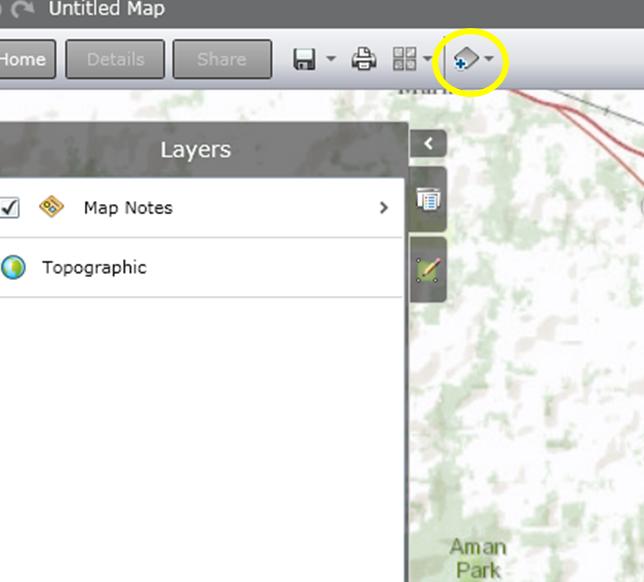
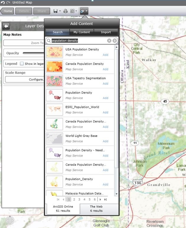
  • To add data, click the button on the top that says “Add Content” and search for the type of information you need.

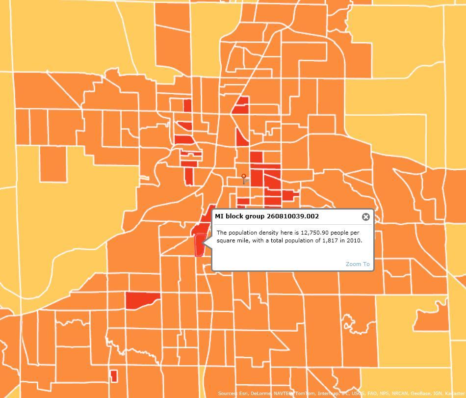
  • When you add the layer, it will show up on the map and be listed on the left side of the screen under “Layers.”  This is a map of population density. The population density map is overlaying the basemap. You can click on a block group to get specific information.


You can also make the layer less opaque in order to see on or more layers of the map at a time. Click the side arrow of the layer in the Layers sidebar.

  • If you press the legend button on the right side of the left sidebar, you can see what the color symbology means.
  • You can even add your own “features,” so if you need to map the locations of something specific or a designated area, you can add points and lines to demonstrate them.


Queries

If you want to really get fancy, you can use Queries to highlight only certain data from the layers. Let’s say you want a list of census tracts with a density lower than 100 persons per square mile. Use a query on the Density layer and click on “Tracts.”

The query will ask you to set the parameters. You want to know the population density, so that’s the first thing you choose. You want to know where tracts are fewer than 100 persons per square male, so you choose “is less than” in the second prompt and type “100” into the third. A window will pop up on the right side of the screen, listing all the census tracts.

Measuring Distance and Calculating Area

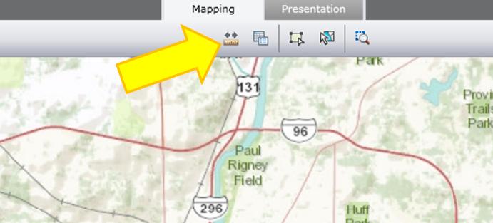
The measure tool is at the top – a ruler with two arrows.

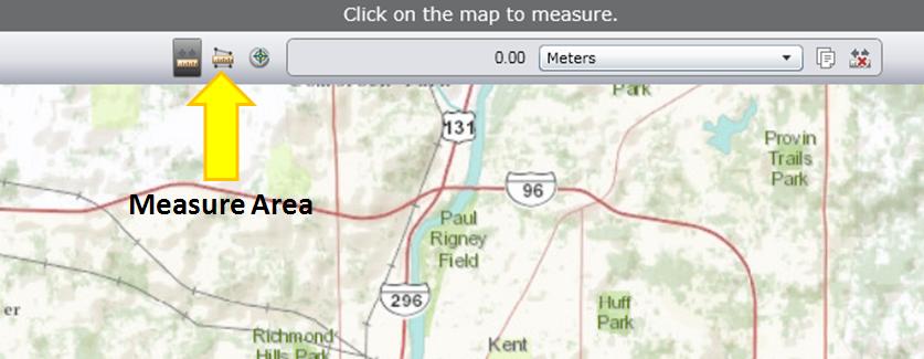
If you click it, you will also have the option to calculate the area using the button next to it, and change the units.

Click one corner of the area you want to measure, then click the next corner, until you have the shape you want. Then click once more on the same spot, and the area calculation should show up at the top with the option to change units.

There’s a growing fear that the Great Lakes water is in danger, and that we need to work quickly to keep people from trying to steal it – or worse, sell and profit from it. Fortunately, this fear is unfounded, based largely on myths about current laws and practices.

Five Myths Great Lakes Water


Myth #1 – We are using too much of the Great Lakes’ water.

On an average day, 150 billion gallons of water arrive in Michigan through rain and snow, and we only use 6.7% of it. The rest stays in our groundwater, lakes, and streams until it evaporates or flows out to the Atlantic Ocean.

Most of the 10 billion gallons that Michigan communities and businesses do use every day goes right back into the water cycle. About 80% is used as cooling water in thermoelectric power plants and released back into the Great Lakes. The remaining 20% is used for public and private drinking water supply, farming, and manufacturing – after which it passes through our drainage or wastewater systems and re-enters Michigan’s lakes and streams.

Myth #2 – Drier areas of the country want to take our water.

Many people are worried about diversions – transporting the Great Lakes water to somewhere outside the Great Lakes watershed. Not only would a large diversion to the Southwest be ridiculously expensive, but there are already legal ways to prevent it. The Water Resources Development Act (passed by Congress in 1986) gives the governor of any Great Lakes state the right to veto any diversion. Moreover, leaders from the Great Lakes Basin states and provinces worked together to create the Great Lakes Charter – an agreement to minimize pollution and prevent diversions. Diversions to the thirsty southwest are not a threat.

Myth #3 – Bottled water companies are a threat to the Great Lakes.

The idea of bottled water companies selling “our” water makes a lot of people anxious, but we have to remember two things. First, hundreds of companies across Michigan already send water out of the Great Lakes Basin in the form of canned goods, processed food, and drinks. These companies have been sending our water all over the world for decades. Our economy has grown, and our environment hasn’t suffered for it. If this water use doesn’t concern us, why should bottled water?

Second, before we worry that bottled water companies will take “too much” water, we need to understand what “too much” means. Any time a company wants to draw significant amounts of water, studies should be performed to determine how much water goes in, how much will be taken out, and if the source can sustain the demands. That’s called sustainability – responsible water use that doesn’t dry up or damage wells, streams, and other sources. The emphasis should be on sustainability (using the right amount) not conservation (using less).

Myth #4 – We can protect the Great Lakes by enacting laws that restrict water use.

A set of bills regulating water use recently passed in Michigan, requiring communities to get DEQ approval before updating their water systems, and requiring businesses to obtain permits and file annual reports if they use significant amounts of water. In addition, a proposed Annex to the Great Lakes Charter requires all Great Lakes states to inventory and regulate their water withdrawals and set conservation goals. And recently, there has been a proposal to prohibit the sale of bottled water outside of the Great Lakes Basin.

These requirements may seem small, yet they have a large – and mostly negative – influence. First, they emphasize conservation, not sustainability. Implying that people should use less water is simplistic, and it’s not feasible if our communities and businesses are to continue to grow.

Second, when communities need permission to grow, they have to spend more time and money to make simple, necessary improvements. When businesses have to jump through expensive hoops (apply for permits, hire consultants to conduct tests, etc.) before they can expand and bring jobs to the state, they might decide to build elsewhere.

Michigan will continue to grow, and we should focus on using water wisely to our economic advantage. Sustainability is the key.

I think we should recruit more bottled water plants. They would bring jobs and tax money toMichigan– just the thing we’re trying to promote. After all, our most abundant resource – the one no one else can match – is fresh water. Let’s help everyone to use it well, rather than stifling our ability to grow.

Myth #5 – The greatest threat to the Great Lakes is over-use.

The greatest threat to the Great Lakes is contamination. We have to start talking about the quality of our water, about soil erosion, toxic waste discharges, and everything that gets through our wastewater system – like microorganisms that are resistant to chlorine, residual chemicals from prescription drugs, and chemicals from our soaps, perfumes, and cosmetics. The EPA is finding all of these in our lakes and streams, and there’s a big concern that these things will end up in our drinking water as well. If we want to protect our water, we should think first about improving its quality, not reducing the quantity that we use.